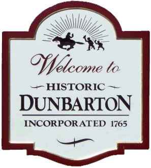
 John Spengler is a descendant of Thomas Jameson, the 1738 Ulster emigrant, who in 1761, settled in Dunbarton, New Hampshire. John gives this first person account of his 1983 travels to Dunbarton and what he found there.
As a determined genealogist and family historian I often travel to distant places to personalize my research as opposed to borrowing information from other sources, such as published genealogies. The study of genealogy is subject to numerous mistakes and conjecture so I often feel that such travel and the gathering of information confirms for me the facts as written and often removes some doubt. Such was the case in the fall of October 1983 when I had the opportunity to travel to Dunbarton, New Hampshire to study the family of Thomas Jameson (1709-1764).
I wanted to see for myself what the countryside was like, learn how the town developed and whether there were historic landmarks that would help me understand how the Jameson family lived and how their involvement with the formation of the town influenced the development of the town. I naturally also wanted to find locally written histories and, of course, headstones.
During my research at the library in Buffalo, New York I had learned of the Jameson’s existence at Dunbarton through publications such as “The History of Medway”, by the Reverend E.O. Jameson, “The Harvey Book”, by Oscar Jewell Harvey and “The Jameson Family”, by G.T. Ridlon, Sr. I was not made aware of Reverend Jameson’s book “The Jameson’s In America” until after I made the trip to Dunbarton, but soon after my return home I obtained a copy.
 Upon my arrival at Dunbarton I immediately made a visit to the town clerk’s office where I purchased a copy of Alice M. Hadley’s publication “Where The Winds Blow Free” a virtual wealth of information regarding the township and the many families who settled there. The clerk also directed me to a few individuals who might have answers to my questions as well as giving me the name and address of Mr. J. Gardiner Mills, the town historian, who had assumed that position after the death of Mrs. Hadley.
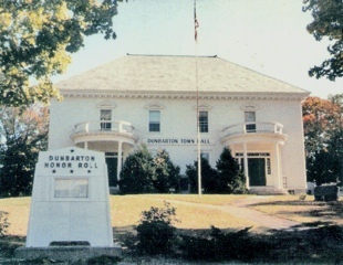
When I departed the clerk’s office I took a walking tour of the town center, enjoying the fine autumn weather and taking many photographs of the historical structures that surrounded the town square. I also visited the cemetery and found dozens of headstones of Jameson family members, including those of my ancestors Thomas and his wife, Margaret. I also made a visit to one of the people that the clerk had suggested and learned from him that Mr. Mills was definitely someone I would want to talk with. Soon I was driving to Mr. Mills address and was immediately welcomed into his home where he had an incredible collection of memorabilia regarding not only the town, but of many of the families as well. I had a very informative visit with him and later received a large mailing from him of many documents pertinent to my research. Later I drove to many historic locations and photographed the blacksmith’s shop, the churches, the town pound (jail) and the homestead of my ancestor’s brother, Hugh Jameson who was another of the earliest settlers of Dunbarton.
After my return home I finally had time to read all of the information that I had gathered as well as the photocopies of documents sent to me by Mr. Mills. In the paperwork I found reference to the home site of my ancestor, Thomas – a place that when I was in Dunbarton I had learned had burned so I hadn’t given thought to finding it. I determined that if I ever had the opportunity to return to Dunbarton that I would look for the remains of Thomas’ homestead.
This opportunity presented itself again, this time in the fall of 1986. I traveled as far as Manchester with family who were vacationing, where I borrowed a car from yet another relative and proceeded to drive to Dunbarton. When I arrived there I learned from the attendant at the historical center that Mr. Mills had been struck by a car during the previous year while retrieving his mail and had soon after died. I was saddened to hear this news as he had been a most helpful resource for information and I had thought him a kind and generous man.
Besides going to Dunbarton my trip to New Hampshire was also with the intent to travel to the town of Antrim where others of my ancestry had lived. I wanted to perform similar research there, but I was also determined to find Thomas’ homestead. The later trip to Antrim proved to be genealogically informative.
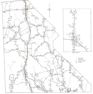 Using Mrs. Hadley’s book, “Where The Winds Blow Free” and a map of the township of Dunbarton that I had purchased as reference, I drove north out of the town center and soon found the location of the “Town Pound”. This was the original jail used by the inhabitants of Dunbarton during the 1700s. According to the book “the property was located about a mile north of town center and a quarter mile east of the town pound”. I was using this simple description as a basis to begin my search for Thomas’ property.
Almost directly across from the Pound on the east side of The Stark Highway I found the entrance to an old roadway, marked on the maps as “1807”. I found this notation a little odd as Mrs. Hadley’s book describes Thomas Jameson’s homestead as follows: Thomas Jameson settled here about 1750. His son John was the next owner followed by Samuel Ryder and son Thomas C. Ryder. Two sets of buildings were burned while owned by Thomas. The second time the buildings burned they were not rebuilt”. While 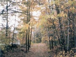 not having anyone to confirm it for me, I made the assumption that this roadway served, perhaps, as the driveway for the Jameson homestead, later to be expanded to meet another road, this one marked “1777”.
The weather was warm and sunny, a beautiful autumn day, perfect for a hike in the woods. The roadway itself was covered with a thick layer of freshly fallen leaves and, despite it looking passable for a car for a distance, I didn’t want to take any chances with a borrowed car. I left it parked at the entrance to the roadway and began hiking into the woods.
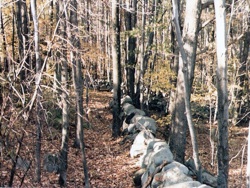 As I advanced farther into the wooded area I found that the road had become overgrown with grass, small saplings and even a young tree here and there, but it was still obviously an old roadway. I followed it for what I measured off as close to a quarter of a mile, watching for signs of anything that might have been a structure or foundation when I noticed a wall of stones on my left. Typical of the early era farmers, when clearing their land they would pile up the stones that they moved and create walls that marked their property lines or enclosed areas of their property. I wandered off the road and looked around extensively, noting the location and the remains of what appeared to be several foundations. I was not entirely convinced that I had found the remains of the Jameson and Ryder properties as these might have been from something constructed at a later date. I returned to the road and followed it, still scanning for evidence of buildings, almost all the way to the “T” at the connecting road, nowadays known as Guinea Road, a well settled highway. Here I turned around and headed back.
 The maps that I had secured showed Thomas Jameson’s homestead as a cellar site marked by an “x” located on the south side of the roadway, but nowhere else on these maps was there a notation of any other building, new or old or cellar site on this roadway. As I hiked back in the direction of where I had parked the car I continued to look for anything that may have been a foundation or evidence of an old structure. I left the road several times thinking that I had seen something that looked like a foundation stone, but was deceived. I soon returned to the site that I had found earlier. Despite the foundations that I found being on the north side of the roadway, I had to assume that because I had not found any other evidence of buildings, that the person who had drawn the map had made a simple mistake when marking the “x”.
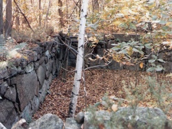
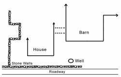
Now convinced that I had found the site of the homestead of Thomas Jameson, I wandered amongst the foundations, taking several photographs and studying how the property had been laid out. To the west was the stone wall that I had first discovered, then more to the east was what appeared to be the foundation of the house. What must have been the barn was adjoining the house foundation, typical of the early New England settlers who, in winter, wanted to be able to access the barn without going outside. This foundation was deep and extensive, running far into the woods that surrounded the location. Dropping into the basement of both the house and the barn I poked around looking for artifacts and found some bits of wood here and there, mostly rotted, but did discover an old teakettle near the old well that was nearer the roadway. While this may have belonged to the Ryder family, I thought it an interesting find so I brought it home.
 For several minutes longer I stood and surveyed the area, enjoying the day and some pleasure in finding what I believed to be the Dunbarton homestead of my ancestor, Thomas Jameson, the first of this extension of the family to make the journey to America to establish a new life.
When I returned to the town center I looked up the man with whom I had spoken three years earlier and described for him where I had just been. He confirmed for me that I had found the remains of what had been the “Ryder Place” and by deduction from the written history must also have been the homestead of Thomas Jameson.
John E. Spengler, N. Collins, N.Y. - Dec 11, 2011 - jspen2074@aol.com

 Dunbarton Chronicles